 Burned Area Emergency Response Tools
| Moscow FSL Home Page | |
| At the lab | |
| Personnel | |
| Modeling Software | |
| Publications | |
| Experimental Forests | |
| News | |
|
Moscow Forestry Sciences Laboratory |
|
|
|
|
Details of Curve Number Methods
The curve number methods consider rainfall, soils, cover type, treatment/conservation practices, hydrologic conditions, and topography (slope steepness). Users have to choose a curve number (CN) based on cover type, treatment, hydrologic conditions, and Hydrologic Soil Group to estimate runoff and peak flow; therefore, the curve number is the single most important parameter in this method.
There are two CN methods that BAER teams frequently use – WILDCAT4 (Hawkins and Greenberg, 1990) is an MS DOS program, and FIRE HYDRO (Cerrelli, 2005) is an EXCEL spreadsheet.
The WILDCAT4 (Hawkins and Greenberg, 1990) model is a storm runoff/hydrograph model that uses triangular unit hydrographs. WILDCAT4 requires the following information:
- name of the watershed;
- average land slope (%) and length of the longest channel (ft) or the time of concentration (hr);
- area (acres) of Hydrologic Response Unit (HRU), which is an area having a consistent hydrologic response;
- CN of HRU;
- storm duration (hrs);
- storm rainfall depth (inches); and
- storm distribution type, either SCS Type II, Farmer-Fletcher (for central and north-central Utah; Farmer and Fletcher, 1972), uniform, custom, or generic.
If a "generic" distribution is chosen, the following information is needed: the minimum and maximum storm intensities (as a percent of the mean storm intensity) and the timing of the peak flow intensity (as a percent of the storm duration).
WILDCAT4 tends to have long times of concentration (Tc). If a shorter Tc is preferred, the user may put a substitute in the Tc formula below (Dunne and Leopold, 1978), which will generate a higher peak flow due to a quicker watershed response to the storm events.
Tc = L 1.15 / (7700 H 0.38) where Tc = time of concentration (hr); L = length of the catchment along the mainstream from the basin outlet to the most distant ridge (ft); and, H = difference in elevation between the basin outlet and the most distant ridge (ft).
WILDCAT4 is recommended for watersheds of 5 mi2 or less. WILDCAT4 is easy to use. However, the user has to specify the CN of pre- and post-fire conditions and the program runs in DOS. WILDCAT5, a Windows version of the WILDCAT program, is in development and will be released in the near future (pers. comm. Hawkins 2008).
Cerrelli (2005) developed a spreadsheet, called FIRE HYDRO, to assist NRCS and Forest Service personnel in estimating design peak flows for the burned areas of Montana. FIRE HYDRO is a peak flow analysis tool for 2-, 5-, 10-, 25-, 50-, and 100-year, 24-hour rainfall runoff events for the pre- and post-fire conditions. The required input data includes the following: drainage area (acre); average watershed slope (%); CN; and 2- to 100-year, 6- and 24-hour rainfall depths that are available from NOAA (2008). The 6- and 24-hour rainfall depths are required to determine the SCS rainfall distribution type (Type I, IA, II, or III). Most of Region 1, including Montana, has Type II, whcih produces the highest peak flow among the SCS rainfall distribution types. Cerrelli (2005) assumed that the runoff Curve Numbers of bare soil cover type or poor hydrologic condition were used for post-fire conditions. However, there is no clear guideline to choose post-fire runoff Curve Numbers. FIRE HYDRO is applicable for 24-hour rainfall events only, and not applicable for short duration rainfall events such as a 1-hour storm or less.
Hydrologic Soil Groups (USDA SCS, 1991)
Low runoff potential and high infiltration rates, and consist chiefly of sands and gravels Moderate infiltration rates, and moderately fine to moderately coarse texture Low infiltration rates, and consist chiefly of soils having a layer that impedes downward movement of water and soils of moderately fine to fine texture High runoff potential and very low infiltration rates, and consist mainly of clay soils, soils with a permanent high water table, or shallow soils over nearly impervious material
Use of Post-Fire CNs by BAER Specialists
There are limited numbers of studies that provide post-fire runoff Curve Numbers. Springer and Hawkins (2005) attempted to provide a guideline to choosing post-fire runoff Curve Numbers based on the 2000 Cerro Grande Fire in New Mexico and concluded that "the post-fire trends in CN and peak flows are not readily explained and will be a topic of future research."
Cerrelli (2005) provided a guideline to select post-fire CN based on burn severity and hydrologic soil grouping specific to the Bitterroot National Forest wildfires. He did not find appropriate CNs in his initial search of the literature for CN values for burned areas in southwestern Montana. Consequently, Montana NRCS engineers created a guideline based on the existing NRCS CN/land use table. However, no gaging or calibrating took place to verify or improve this guideline. New protection practices (e.g. road treatments) were implemented using these newer NRCS guidelines. In the spring and summer following the fires, the region experienced its 2- and 5-year, 24-hour storm events and the new protection practices were not adversely affected.
1 High burn severity areas were assumed to have attained at least 30% ground cover consisting of vegetation, duff, thick ash, or woody debris by June of the following year after the fire, and the CN values were from three Montana NRCS engineers with hydrologic evaluation experience. 2 Hydrologic Soil Group 3 Refer to USDA SCS (1991) 4 Rule of thumb by Montana NRCS
Story (2003) circulated an e-mail to suggest the following post-fire CNs for Region 1.
Post-fire condition
High burn severity with water repellent soils High burn severity without water repellent soils
Stuart (2000) used FIRE HYDRO (Cerrelli 2005) to estimate storm event peak flow on the 2000 Maudlow Fire, Montana. Based on observations of unburned conditions, land type/cover type, burn intensity, and water repellency conditions, the following CNs were selected.
Post-fire condition1
Moderate burn severity Low burn severity Unburned Moderate burn severity with BAER treatments2 Low burn severity with BAER treatments
1 There was no high burn severity area in the Maudlow Fire area. 2 The combination of seeding, contour-felling, fencing, and road drainage would reduce CN.
Kuyumjian, Greg. [Personal note]. Greg's Curve Number thoughts.
Post-fire condition
High burn severity with water repellent soils High burn severity without water repellent soils Moderate burn severity with water repellent soils Moderate burn severity without water repellent soils Low burn severity Straw mulch with good coverage Seeding with LEBs1-one year after fire LEBs without water repellent soils
1 Log Erosion Barriers
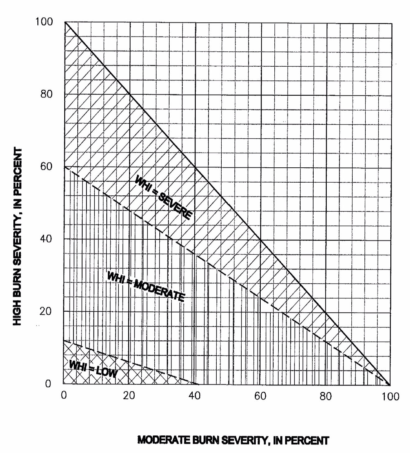
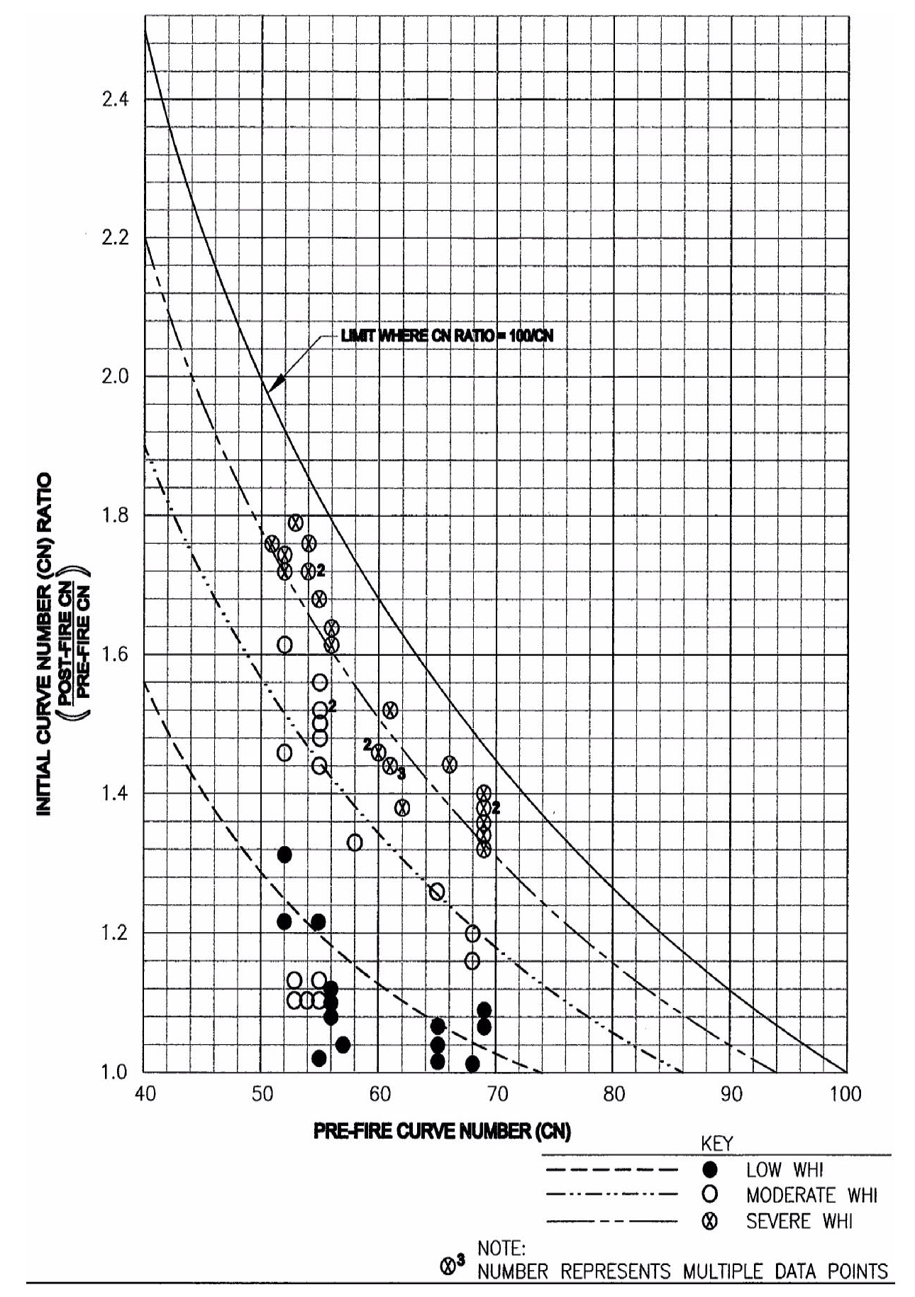
Livingston and others (2005) provided a guideline to choose the post-fire CNs with a range of values. They used computed CNs and compared pre- and post-fire CNs for 31 small (0.12 to 2.5 mi2) subbasins in the Los Alamos area in New Mexico, and 24 small (0.11 to 2.3 mi2) subbasins affected by the 2002 Long Mesa Fire at Mesa Verde National Park in Colorado. Their study results are applicable to the Los Alamos area and other areas in the southwest with similar pre-fire CN values and hydrology; however, they are not applicable to areas with different pre-fire rainfall and runoff characteristics.
Soil burn severity
High, with water repellent soils High, without water repellent soils Moderate, with water repellent soils Moderate, without water repellent soils Low Unburned
To classify the soil burn severity of the whole watershed/basin, they used Wildfire Hydrologic Impact (WHI), based on the percentage of high and moderate soil burn severity, and a general relation between pre- and post-fire CN ratio. The WHI can be determined using the table or figure below.
After Livingston and others (2005)
Post-fire runoff curve number can be estimated using the figure below if pre-fire CN is known.
After Livingston and others (2005)
U.S. Forest Service Coronado National Forest (2003)
U.S. Forest Service Coronado National Forest (2003) used WILDCAT4 (Hawkins and Greenberg 1990) to estimate peak flow runoff in key watersheds under pre-and post-fire conditions on the 2003 Aspen Fire, Arizona. Limited sampling of water repellency conditions indicated moderate water repellency occurred on severely burned soils.
Since there are very limited studies and guidelines for choosing CNs for post-fire conditions, BAER team members often use simple rules of their own. Details on these rules are found in the NRCS CN Methods, section 3.6.2. For example, in the Salt Creek BAER Hydrology Special Report, Higginson and Jarnecke (2007) used WILDCAT4 (Hawkins and Greenberg 1990) to estimate pre- and post-fire runoff on the 2007 Salt Creek Fire, Utah. They used the following rules to determine post-fire CNs (limiting CN to a maximum of 100).
Condition CN value High burn severity pre-fire CN + 15 Moderate burn severity pre-fire CN + 10 Low burn severity pre-fire CN + 5
Solt and Muir (2006) used WILDCAT4 (Hawkins and Greenberg 1990) to estimate pre- and post-fire runoff on the 2006 Warm Fire, Utah. The limestone derived soils of the burned area were determined to be in Hydrologic Soil Group D (low infiltration) and in the ponderosa pine/juniper vegetation type. The following CNs were selected.
Condition Pre-fire High burn severity Moderate burn severity Low burn severity and unburned
The user has to determine pre-fire and post-fire CN, which is a sensitive parameter; therefore, the estimated peak flow is subjective to users.
Underestimation of Post-Fire Runoff
Once the user has determined CNs for each HRU within a watershed, the problem arises of how to combine them. CNs and runoff depth are not linearly related, but curvilinearly related (Grove and others 1998). A weighted average of all CNs in a watershed is commonly used to reduce the number of calculations. The underestimation of runoff using weighted average CNs is most severe for wide CN ranges, as would occur in watersheds containing low and high severity burns. Low CN values and low precipitation depths, as would occur in unburned southwestern watersheds, would result in underestimation of runoff. Therefore, care should be exercised when applying weighted average CNs.
Another approach is to use distributed CNs in a GIS application. However, White (1988) and Stuebe and Johnston (1990) reported that using distributed CNs resulted in as much as 100 percent higher runoff than using weighted average CNs.
The preferred method to estimate runoff from watersheds with different CNs is to combine runoff amounts from each HRU.
REFERENCES
Cerrelli, G. A. 2005. FIRE HYDRO, a simplified method for predicting peak discharges to assist in the design of flood protection measures for western wildfires. In: Moglen, Glenn E., eds. Proceedings: 2005 watershed management conference-managing watersheds for human and natural impacts: engineering, ecological, and economic challenges; 2005 July 19-22; Williamsburg, VA. Alexandria, VA: American Society of Civil Engineers: 935-941.
Dunne, Thomas; Leopold, Luna B. 1978. Water in environmental planning. New York, NY: W. H. Freeman and Company. 818 p.
Farmer, E. E.; Fletcher, J. E. 1972. Rainfall intensity-duration-frequency relations for the Wasatch Mountains of northern Utah. Water Resources Research. 8(1): 266-271.
Grove, Matt; Harbor, Jon; Engel, Bernard. 1998. Composite vs. distributed curve numbers: effects on estimates of storm runoff depths. Journal of the American Water Resources Association. 34(5): 1015-1023.
Hawkins, R. H.; Greenberg, R. J. 1990. WILDCAT4 Flow Model. [This edition further enhances Moore's version] School of Renewable Natural Resources, University of Arizona, Tucson, AZ. BLM contact: Dan Muller, Denver, CO.
Higginson, Brad; Jarnecke, Jeremy. 2007. Salt Creek BAER-2007 Burned Area Emergency Response. Provo, UT: Uinta National Forest; Hydrology Specialist Report. 11 p.
Livingston, Russell K.; Earles, T. Andrew; Wright, Kenneth R. 2005. Los Alamos post-fire watershed recovery: a curve-number-based evaluation. In: Moglen, Glenn E., eds. Proceedings: 2005 watershed management conference-managing watersheds for human and natural impacts: engineering, ecological, and economic challenges; 2005 July 19-22; Williamsburg, VA. Alexandria, VA: American Society of Civil Engineers: 471-481.
National Oceanic and Atmospheric Administration. (2008, March 19-last update). NOAA's National Weather Service Hydrometeorological Design Stduies Center [Hompage of HDSC], [Online]. Available: https://www.nws.noaa.gov/oh/hdsc [2008, May 6].
Solt, Adam; Muir, Mark. 2006. Warm Fire--hydrology and watershed report. Richfield, UT: U.S. Department of Agriculture, Forest Service, Intermountain Region, Fishlake National Forest. 9 p.
Springer, Everett P.; Hawkins, Richard H. 2005. Curve number and peakflow responses following the Cerro Grande Fire on a small watershed. In: Moglen, Glenn E., eds. Proceedings: 2005 watershed management conference-managing watersheds for human and natural impacts: engineering, ecological, and economic challenges; 2005 July 19-22; Williamsburg, VA. Alexandria, VA: American Society of Civil Engineers: 459-470.
Story, Mark. 2003. [E-mail circulation]. September. Stormflow methods.
Stuart, Bo. 2000. Maudlow Fire, Burned Area Emergency Rehabilitation (BAER) plan. Townsend, MT: U.S. Department of Agriculture, Forest Service, Northern Region, Helena National Forest.
Stuebe, M. M.; Johnston, D. M. 1990. Runoff volume estimation using GIS techniques. Water Resources Bulletin. 26(4): 611-620.
U.S. Department of Agriculture, Soil Conservation Service. 1991. Engineering field handbook: chapter 2-estimating runoff. In: National engineering handbook. Washington, D.C.: U.S. Department of Agriculture, Soil Conservation Service: part 650.
U.S. Forest Service Coronado National Forest. 2003. Aspen Fire, Coronado National Forest, BAER hydrology report. Tucson, AZ: U.S. Department of Agriculture, Forest Service, Southwestern Region, Coronado National Forest.
White, D. 1988. Grid-based application of runoff curve numbers. Journal of Water Resources Planning and Management. 114(6): 601-612.
Modified July 17, 2013
USDA Forest Service - RMRS - Moscow Forestry Sciences
Laboratory
Last Modified: